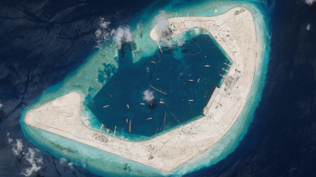
The return of Chinese cutter suction dredgers to the southwestern sector of the Paracel Islands represents the termination of an eight-year equilibrium. Between 2017 and late 2025, Beijing’s island-building operations within the South China Sea remained functionally dormant, leading many regional observers to conclude that the geographic architecture of its maritime projection had reached structural maturity. The intensive engineering at Antelope Reef (Lingyang Jiao) invalidates that assumption.
By expanding a historically minor outpost into an island mass measuring approximately 1,490 acres, China is executing a calculated reconfiguration of its northern maritime tier. This operation cannot be understood through the lens of mere territorial assertiveness; it must be quantified as a logistical and tactical optimization of the People’s Liberation Army (PLA) power projection capability.
The Operational Mechanics of Rapid Reclamation
The scale of expansion at Antelope Reef—growing from a submerged coral feature to a 6-square-kilometer landmass within approximately six months—highlights a highly synchronized domestic supply chain and specialized fleet deployment. The operation relies on the world’s largest fleet of cutter suction dredgers (CSDs).
The mechanism of this rapid land reclamation operates via a clear industrial cost function:
Total Reclaimed Volume = Fleet Dredging Capacity (m³/hr) × Operational Hours × Sediment Transport Efficiency
To achieve this scale, heavy industrial assets like the Tian Kun Hao or similar vessels break apart seabed coral and limestone formations using a rotating cutter head. The loosened material is then drawn up via high-power centrifugal pumps and discharged through floating pipeline networks directly onto the reef flat.
This process eliminates the logistical bottleneck of transporting dry fill from mainland ports, allowing individual high-capacity dredgers to deposit up to 6,000 cubic meters of material per hour. Once deposited, the saturated sediment is systematically drained, leveled, and stabilized using heavy engineering equipment. To mitigate the structural vulnerability of porous coral sand under heavy loads, the baseline engineers employ specialized additives, including ultra-high performance concrete integrated with local coral aggregates, ensuring a foundation capable of supporting heavy military hardware.
The Three Pillars of Strategic Value
The development of Antelope Reef is not a redundant exercise in land creation, despite its proximity to the established air and naval infrastructure on Woody Island. Instead, the feature serves three critical architectural purposes within China's maritime defense system.
1. The Redundancy and Dispersal Framework
Woody Island, measuring approximately 890 acres, serves as the administrative and military nerve center for the Paracels. However, concentrated military assets present a high-value, high-vulnerability target in a kinetic conflict. At 1,490 acres, Antelope Reef provides the physical space required to distribute military assets, creating operational redundancy. If an adversary neutralizes the runways or radar installations at Woody Island, the operational capability transfers to Antelope Reef, preventing a single-point-of-failure scenario in the northern sector.
2. The Sensor Network and A2/AD Optimization
Antelope Reef sits 162 nautical miles from China’s Sanya naval base on Hainan Island and 216 nautical miles from Da Nang, Vietnam. This geographic positioning closes a critical gap in China’s Anti-Access/Area Denial (A2/AD) envelope. Integrating high-frequency surface-wave radar, tropospheric scatter communications, and electronic warfare suites on the new landmass extends China's persistent sensory horizon directly to the Vietnamese coastline. The straight-line outer northwestern edge of the reef, spanning over 11,000 feet, is structurally optimized to support a 9,000-foot military-grade runway, matching the capabilities of the "Big Three" outposts in the Spratly Islands (Mischief, Subi, and Fiery Cross reefs).
3. Logistical Sustainment for Parastatal Fleets
The deep lagoon enclosed by the crescent-shaped geography of Antelope Reef forms a protected anchorage that dwarfs existing harbors in the Crescent Island group. This lagoon functions as a forward staging base for the China Coast Guard (CCG) and the People’s Armed Forces Maritime Militia (PAFMM).
Sustainment Multiplier = (On-Station Time + Fleet Density) / Transit Depreciation
By providing localized refueling, berthing, and basic maintenance capabilities, China eliminates the requirement for these vessels to make the cyclical return journey to Hainan. This alters the economics of presence, allowing a higher density of hulls to remain in contested waters indefinitely.
The Friction Function: The Geopolitical Catalyst
The timing of the Antelope Reef expansion reveals a direct cause-and-effect relationship with shifts in regional maritime activity. Since 2021, Vietnam has quietly accelerated its own land reclamation campaign in the Spratly Islands, creating hundreds of acres of new land across multiple features. This asymmetric expansion threatened to alter the relative balance of held territory.
The Antelope Reef operation acts as a structural correction. By leveraging superior industrial dredging capacity, Beijing rapidly offset Vietnam's multi-year cumulative gains in a fraction of the time. The diplomatic silence from the broader international community, distracted by concurrent conflicts in the Middle East and shifting Western political priorities, created a permissive strategic window that minimized the diplomatic costs of the deployment.
Strategic Forecast
The completion of the primary dredging phase at Antelope Reef signals a transition from raw geographical alteration to structural fortification. The next phase will involve the installation of permanent infrastructure:
- Phase 1 (Complete): High-volume sand extraction, perimeter stabilization, and creation of basic harbor entryways.
- Phase 2 (Current): Construction of specialized concrete batching plants, deployment of prefabricated structural units, and laying of aviation foundations.
- Phase 3 (Imminent): Integration of surface-to-air missile (SAM) batteries, anti-ship cruise missile (ASCM) emplacements, and hardened underground ammunition and fuel storage vaults.
The strategic play is clear: Antelope Reef will not remain a mere logistics outpost. It is engineered to become the dominant tactical node in the northern South China Sea, locking down the Western approach to Hainan Island and establishing permanent, unblinking surveillance over Vietnam's eastern maritime approaches. Regional actors must now adjust their defensive postures to account for a permanent, heavily armed dual-runway capability in the Paracel Islands.


