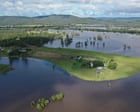
When Peter Lake bought his cattle property in the Clarence Valley back in 2007, he went in with his eyes wide open. He knew his farm sat right on flood country, tucked along the Coldstream River between Yamba and Grafton in New South Wales. But nobody could anticipate just how fast the margins for survival would shrink. His property has flooded five times since 2009, and the high ground he relies on to save his cattle is disappearing inch by inch.
Safe land in Australia is vanishing. Fast. For another view, check out: this related article.
Recent modeling from the Climate Council paints a grim picture of the country's immediate future. We are looking at a staggering $855.1 billion in economic losses by the end of the century due to coastal flooding. Over 267,000 coastal properties and nearly two million hectares of land face severe damage as sea levels keep creeping upward.
You aren't just hearing about abstract environmental projections anymore. You are seeing the physical reality on places like Peter's farm, where rising tides and intense storm surges turn productive acreage into temporary inland seas. Similar coverage on this matter has been provided by The New York Times.
The Trillion-Dollar Bill Hiding in Our Coastal Zones
Let's look at the numbers because they refuse to lie. Professor Tom Kompas from the University of Melbourne co-authored a landmark study published in Scientific Reports that breaks down the structural financial catastrophe heading our way. Out of that $855.1 billion price tag, about $274.3 billion comes straight from property damage, while a massive $580.7 billion represents lost land use and agricultural devastation.
States like Queensland, New South Wales, and Western Australia carry the heaviest burden. Queensland alone has over 93,000 properties in the crosshairs. Urban centers aren't safe either. Melbourne's low-lying pockets around Port Phillip Bay and the Yarra River face relentless threats, while the Gold Coast stands as one of the most economically exposed urban strips on the continent.
Yet, local councils and developers keep approving new structures on vulnerable floodplains. It defies basic logic. We keep building hard assets in paths of water that grow wider every single decade.
What Happens When the High Ground Disappears
For graziers and farmers operating in low-lying coastal regions, survival depends entirely on vertical buffers. Peter Lake has standard emergency protocols down to a science. When the river breaks its banks, he moves his cattle to designated dry paddocks and truckloads in extra fodder to keep them fed until the water recedes.
It works, but only because some high ground remains.
During the severe floods of 2022, that margin evaporated. Peter noted that out of his 130 acres, only a tiny handful of acres stayed above water. When high ground shrinks to almost nothing, standard farm management breaks down. You can't rotate livestock on dirt that doesn't exist. Crop cultivation on his property stopped entirely years ago because the risk profile makes routine farming financially impossible.
This creates a secondary crisis most urban planners ignore: food security. When hundreds of thousands of hectares of prime agricultural land face regular saltwater intrusion and permanent waterlogging, local supply chains feel the shockwaves.
Why Adaptation Plans Are Failing Us
Global emissions targets get all the political oxygen, but local adaptation receives almost zero meaningful execution. Sea levels have already climbed more than 22 centimeters globally since 1900. Australia expects another 14-centimeter jump by 2050. That extra cushion changes everything. High tides that used to stay within legal boundaries now spill over docks, roads, and pastures on a regular monthly cycle.
Experts point out a glaring institutional failure. The absolute number one rule of living near the coast is refusing to build on low-lying floodplains. Yet, planning boards continue approving residential and commercial subdivisions in precisely these zones, leaving future buyers holding worthless deeds and impossible insurance bills.
Insurance companies are already quietly pulling back or pricing policies out of reach. Property owners in hotspots from Northern Rivers down to Gippsland find themselves trapped. They can't sell because buyers know the risks, and they can't afford to elevate or relocate structures without heavy government backing that rarely materializes.
Protecting What Left We Have
If you own property or run a business near tidal rivers or low-lying coastal flats, waiting for policy changes from capital cities is a losing game. Real risk management starts on the ground level.
First, audit your elevation profiles. Don't trust historical flood markers from thirty years ago because modern storm surges stack on top of higher baseline sea levels.
Second, rethink land utilization. If traditional crops or continuous livestock grazing on flood-prone flats yields diminishing returns, transition those low acres into wetland buffers or specialized aquaculture that thrives during inundation cycles.
Finally, stop treating every major flood as a once-in-a-century anomaly. They are regular calendar events now. Plan your capital investments around properties that actually retain high ground when the worst-case scenario arrives.