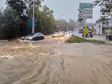
Urban drainage failure is rarely an isolated meteorological anomaly. When intense precipitation overwhelms municipal infrastructure, the ensuing crisis exposes systemic vulnerabilities in topography, land-use planning, and discharge capacity. Heavy rainfall events that paralyze metropolitan areas and result in structural collapse or fatalities are symptoms of an economic and engineering mismatch between historical capacity and modern hydrological stress.
Analyzing a major flooding event requires deconstructing the failure across three operational vectors: the surface runoff coefficient, the hydraulic bottleneck of subterranean conduits, and the emergency response latency. Understanding how these factors interact reveals why standard municipal designs break down during extreme weather anomalies.
The Surface Runoff Coefficient and Impervious Cover
The primary driver of urban flooding is the alteration of natural hydrological cycles through intensive urbanization. Natural terrain absorbs precipitation through vegetation and permeable soils, moderating the velocity and volume of water reaching natural watercourses. Megacities replace this permeable matrix with asphalt, concrete, and densely packed structures, drastically increasing the runoff coefficient.
When precipitation intensity exceeds the infiltration rate of the urban fabric, surface water accumulates rapidly. This accumulation creates overland flow regimes that follow topographical gradients, turning streets into high-velocity channels.
Precipitation Intensity > Soil Infiltration Rate = Exponential Runoff Increase
Without adequate vegetative buffers or localized retention basins, stormwater moves unimpeded toward lower-elevation commercial and residential zones. The lack of permeable surface area means that every millimeter of rainfall translates almost directly into dynamic surface volume, overwhelming stormwater inlets before it ever reaches primary drainage channels.
Hydraulic Bottlenecks in Subterranean Conduits
Subsurface drainage networks are engineered around historical rainfall frequency and intensity curves, typically calculated using statistical models such as the rational method or intensity-duration-frequency curves based on past meteorological data. When climate volatility shifts precipitation patterns, these legacy drainage systems operate beyond their maximum designed discharge capacity.
A subterranean conduit system functions under specific hydraulic pressure gradients. When volume exceeds the cross-sectional area of the pipe, flow transitions from open-channel flow to pressurized pipe flow. This transition introduces severe operational risks:
- Surcharge and Backflow: Pressurized conduits push water upward through manholes and street inlets, creating geysers that flood intersections regardless of local elevation.
- Sedimentation and Debris Loading: Urban runoff carries high loads of solid waste, silt, and construction debris. These materials settle in low-velocity sections of the network, reducing effective cross-sectional area and choking outflow efficiency.
- Outfall Submergence: If coastal or river-adjacent outfalls become submerged due to high receiving-water levels, gravity-fed drainage stalls completely, causing a hydraulic backup across the entire upstream network.
These structural limitations mean that even clean, well-maintained drainage networks will experience functional failure when instantaneous precipitation volume outstrips physical transport capacity.
The Cost Function of Infrastructure Deficits
Municipalities face a difficult capital allocation challenge regarding flood mitigation. Drainage infrastructure is invisible, highly capital-intensive, and yields no direct short-term revenue. Consequently, capital expenditure tends to lag behind urban densification.
When infrastructure investments are calculated using linear projections of historical weather data, the economic model fails to account for extreme tail-risk events. The cost function of underinvestment becomes apparent only during catastrophic events, where the economic losses—ranging from asset destruction to supply chain paralysis and loss of life—far exceed the capital required for high-capacity upgrades.
Furthermore, maintenance deferred on storm drain clearing, pump station overhauls, and silt removal creates an invisible compound debt. When a heavy rain event occurs, this deferred maintenance manifests as sudden, synchronized failures across multiple critical nodes of the municipal network.
Emergency Response Latency and Information Asymmetry
Mitigating the human toll of urban flash floods depends entirely on operational response velocity. The interval between meteorological radar detection, official warning dissemination, and public evacuation is frequently compromised by institutional friction and communication delays.
Detection Time -> Transmission Latency -> Municipal Response -> Public Action
In high-density environments, localized flash flooding occurs within minutes of peak precipitation intensity. Traditional emergency management structures often rely on centralized command hierarchies that struggle to process real-time telemetry from distributed sensor networks. This information asymmetry results in citizens entering subterranean transit systems, underground parking facilities, or low-lying roadways unaware of rapidly rising water levels.
Strategic Operational Recommendations
To alter the outcome of future extreme precipitation events, municipal authorities and urban planners must transition from reactive disaster management to proactive structural adaptation.
- Dynamic Capacity Modeling: Abandon stationary historical precipitation baselines in favor of dynamic climate simulation models that incorporate high-variance precipitation spikes.
- Decentralized Retention Networks: Implement micro-retention strategies, including permeable pavements, engineered wetlands, and rooftop detention systems, to flatten the peak runoff hydrograph before it enters primary subterranean conduits.
- Automated Subsurface Monitoring: Deploy real-time telemetry and automated valve controls within drainage networks to reroute flow away from saturated zones and prevent catastrophic backflow.
- Real-Time Public Warning Integration: Connect meteorological radar feeds directly to automated public transit shut-off mechanisms and mobile emergency alert systems, eliminating bureaucratic latency during critical response windows.